

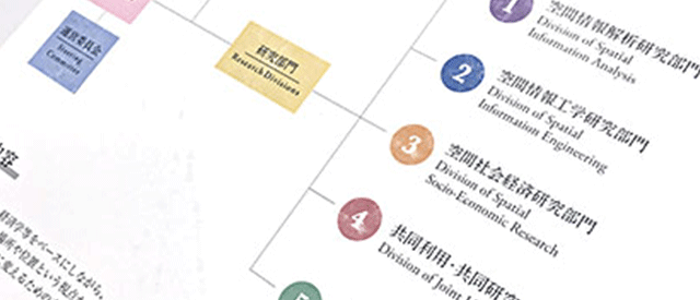


Research Divisions
CSIS comprises the following research divisions to promote spatial information science.
Division of Spatial Information Analysis
This division develops methods for extracting spatial characteristics such as the shape and distribution of various spatial phenomena including landforms, hydrology, vegetation, society, culture, language, and economy. The division also develops and applies spatial analysis theory to uncover the underlying mechanisms. In addition, the division developed a system to support spatial decision-making that contributes to the planning processes of real society, for example, to predict future phenomena or analyze policies.
Division of Spatial Information Engineering
This division conducts research on various techniques and integrates and mines methods to efficiently obtain an enormous volume of data connected to location and time generated by various sensors dispersed throughout a real space. Furthermore, data reflecting the conditions of real spaces dispersed on the Internet are collected. This division also studies extensive applications based on spatio-temporal data such as data visualization, location information services, and future prediction.
Division of Spatial Socio-Economic Research
The aim of this division is to promote theoretical and empirical studies on diverse social and economic phenomena, focusing on their spatio-temporal characteristics. Furthermore, the division develops methods to statistically analyze the spatio-temporal data needed in empirical analyses. It also constructs spatio-temporal databases that are made available to researchers across Japan to enhance empirical research in the social sciences, in particular, in urban and regional economics.
Division of Joint Usage and Research
This division reconstructs scattered spatial data and spatial knowledge to compile a spatial information base. It conducts research and development activities focused on environments that support research and educational activities related to these data and that use them in sophisticated applications. In addition to designing, implementing, and validating initiatives directed at the development of research communities, this division studies the environments, methods, and systems needed to promote social applications of the spatial information base.
Division of Spatial Formation for Innovation Hubs and its Evaluation
This division investigates the formation of innovation hubs from a spatial perspective. It analyzes the location dynamics of startups and the effectiveness of innovation promotion measures implemented in incubation facilities both quantitatively and qualitatively so as to obtain insights into regional and spatial developments that attract new startups and support their growth.
Joint Organization of Digital Spatial Society Research
The Joint Organization of Digital Spatial Society Research centrally aggregates diverse and dynamic real-time spatio-temporal big data such as data from IoT devices. data-driven technology and science, while organically linking researchers in related fields within the university while constructing a digital social space that encompasses the expansion and changes in the environment, as well as the transformation and fluctuation of socio-economic systems. We will deepen it further and build new theories of real-time spatio-temporal data analysis and application. At the same time, we aim to develop research results into data-driven industries and help solve international social issues.
Division of Global Spatial Data Commons Initiative
This division promotes the self-directed social deployment and operation of digital twins in each region by implementing digital twins for entire cities and supporting the emergence of technologies to resolve various local issues from the private sector and other stakeholders. Consequently, the division aims to form global spatial data commons. Additionally, the division provides data handling and training for private companies and local governments to promote human resource development.
Division of Civic Tech Design Initiative
This division promotes the use of data and digital applications for regions and communities through the involvement of diverse stakeholders such as citizens and local businesses, with the Collaborative Research Organization for the Digital Spatial Society. Additionally, the division creates and develops learning and practice opportunities in various regions where each person can be proactively and consistently involved in the solution development process. And it provides opportunities for diverse dialogues, co-creation and experiences and builds a foundation to nurture and support activities that raise the digital power of the community through a bottom-up approach.
部門構成
「空間情報解析研究部門」「空間情報工学研究部門」「空間社会経済研究部門」「共同利用・共同研究部門」の4部門の構成で、研究開発と研究・教育支援を行っています。また「デジタル社会空間」をデータ基盤の上に構築し、学内関連分野の研究者を有機的に連携するために、「デジタル空間社会連携研究機構」を空間情報科学研究センターが主体となり、学内18部局とともに運営しています。
地理学、工学、情報学、経済学等をベースにしながら、世の中の様々なデータを場所や位置という視点から整理し、使いやすく役に立つ「情報」に変えるための方法を研究しています。
空間情報解析研究部門
地形、水文、植生、社会、文化、言語、経済など多様な空間現象について、形状や分布などの空間的特徴を抽出する手法を開発し、背景にあるメカニズムを解明するための空間解析理論の構築と適用を行います。また、現象の将来予測や政策分析など、実社会の計画立案に資する空間意思決定支援システムも開発しています。
空間情報工学研究部門
実空間に置かれたセンサ群から生成される場所や時間に紐づいた莫大なデータや、インターネット上に散在する実空間の様相を反映したデータを効率良く取得するための諸技術、統合・マイニング手法の研究を行います。また、データの可視化、位置情報サービス、将来予測など、これらの時空間データに基づいた幅広い応用の研究を行います。
空間社会経済研究部門
時間と空間を切り口にさまざまな社会経済現象を分析し、社会経済問題の理解と解決を目指しています。分析は理論と実証の両面から行います。また、実証分析に必要となる時空間データの統計解析手法を開発します。さらにこれらと合わせ、全国の研究者が共用できる時空間データ基盤システムを整備することにより、都市・地域経済学を中心とする社会科学分野における実証研究の発展を促進していきます。
共同利用・共同研究部門
分散して存在する空間データや空間知識を空間情報基盤として再構築し、それらを連携させ高度利用する研究・教育支援環境を研究・開発しています。また、研究コミュニティの発展のためのイニシアティブの設計・実施・検証を行うとともに、空間情報基盤の社会的利用促進に必要となる環境・方法・制度の研究も行います。
イノベーション拠点の空間形成と評価 社会連携研究部門
本部門ではイノベーション拠点の形成を空間的な視点から研究しています。スタートアップ企業の立地動態およびインキュベーション施設におけるイノベーション促進施策の効果を、定量的・定性的に分析・評価して、新たなスタートアップ企業を誘引し、その成長を後押しする地域づくり・空間づくりのための知見を、実証的に明らかにします。
デジタル空間社会連携研究機構
デジタル空間社会連携研究機構ではIoTデバイスからのデータなどの多様でダイナミックなリアルタイム時空間ビッグデータを一元的に集約し、これらを統合した形で人々や企業の活動、交通・物流・商流から都市の拡大・環境変化、社会経済システムの変質・変動までを包含するデジタル社会空間をデータ基盤の上に構築すると共に学内関連分野の研究者を有機的に連携しつつ、データ駆動型の技術・サイエンスにより深化し、リアルタイム時空間データ解析・応用の新たな学理を構築します。同時に研究成果のデータ駆動型産業への展開と国際的な社会課題の解決支援につなげることを目指しています。詳細は こちら です。
グローバル空間データコモンズ社会展開 寄付研究部門
本部門では、まち全体のデジタルツイン化を行うとともに、各種地域課題のソリューション技術が民間等から出てくるように支援する事により、各地域のデジタルツインの社会展開・運営の自律化を促し、グローバルな空間データコモンズの形成を図ります。また、民間企業や地方自治体等のデータハンドリング・研修等を行い、人材育成を進めます。
シビックテック・デザイン学創成 寄付研究部門
デジタル空間社会連携研究機構と市民や地域企業といった多様なステークホルダーが関わることで、地域やコミュニティのためのデータ・デジタル活用を進めます。また、ソリューション開発過程に一貫して関わることができる学びや実践の場を各地に創成・展開します。多様性の豊かな対話と共創や多様な経験の機会を提供し、地域のデジタル力をボトムアップ的に底上げするような活動を育て・サポートしていく基盤を構築します。